Barbados Meteorological Services Issues Flash Flood Watch Due to Excessive Rainfall: High Risk of Flooding in Low-Lying Areas

September 1, 2024
Barbados Meteorological Services issues flash flood watch due to excessive rainfall, potential flooding in low-lying areas. Unstable conditions may lead to heavy showers, thunderstorms, and possible impacts like significant flooding and commuting delays. Public advised to stay informed through official channels.
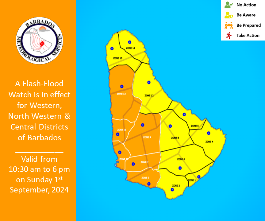
The Barbados Meteorological Services (BMS) has issued a flash flood watch with excessive rainfall this afternoon possibly generating flooding across low-lying areas of the watch area.
The BMS says unstable conditions along with light winds and strong daytime heating may result in localised activity across the western, northwestern and central districts of the island.
Cloudy periods with scattered moderate to heavy showers and isolated thunderstorms are forecast for late this morning and into the afternoon, which could result in rainfall accumulation of two to three inches (50mm to 75mm).
Possible Impacts:
There is the high possibility of significant flooding which may result in soil erosion on bared or scarred land surfaces.
Noticeable increases in water levels of existing water bodies.
Time-consuming commuting delays with some roads becoming impassable in and out of the city.
What you should do: The public should follow recommendations from the DEM and monitor the BMS, DEM and GIS websites and their respective social media pages along with the local media networks for further updates.
A flash flood watch is issued when heavy or excessive rainfall in a short period of time (generally less than six hours) could result in flash flooding within the watch area. It does not mean that flooding will occur, but it is possible.
This flash flood Watch was issued at 10:30 a.m. and will be terminated at 6 p.m. or sooner if conditions warrant.


